Rising to the Ultimate Challenge!
- Feb 20
- 8 min read
Updated: Mar 2

An award winning & published account of a high level crossing of Scotland- from Shiel Bridge to Montrose... with thanks to climbing partner Mal Newlyn for the original photographs.
Introduction
The 'Ultimate Challenge', 11-20th May, 1984, was a cross-Scotland long distance walk sponsored by The Great Outdoors Magazine and Ultimate Equipment Ltd. It was not a race, but a challenging self-supported backpacking trek across Scotland starting on the west coast and finishing on the east coast.
All planning was by the participants who could choose to plan a low level route or a high level route (to include at least 12 Munros and/or Corbetts). In 2026 it is named the TGO (The Great Outdoors) Challenge.
My Munro bagging team duly entered, being Ian Holland (31), Malcolm Newlyn (36) and myself, Neville Wiseman (44). There was an equipment prize for the best High Level Account and the best Low Level Account.
The best written account in each category would be published in the November 1984 edition of “The Great Outdoors Magazine.” We won the “Best High Level Account”, and this is replicated in the Magazine, and below.
Gone Paddling- Back Soon
Coming from the seaside holiday town of Blackpool, we got a few funny looks when we announced our intention to go paddling in Scotland for our holidays. We ignored recommendations to pack our bucket and spade and settled for a plastic bowl and a spoon.
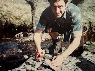
We were off on The Ultimate Challenge, to put one foot in the North Atlantic/Irish Sea at Shiel Bridge (photo above) and the other in the North Sea at Scurdie Ness, Montrose (not both at the same time, you must understand).
Knowing that the weight factor would be crucial, we cut our rucksack weights to 18lb personal and 6lb communal gear. When many fellow travellers were seen staggering with 35-55lbs, we were thankful for our frugality.
To minimise the food weight problem, and the effects of bad weather, we decided that we would try to camp and Bed and Breakfast on alternate nights. Food parcels were planted at Spean Bridge and at Dalwhinnie.
Prayers & Progress
With the snow on the ridges and in the gulleys looking like freshly-squeezed toothpaste... and the hills beckoning... we splashed enthusiastically into Loch Duich. It was great to be alive!
Two omens attracted our attention. The first was a cuckoo, telling us repeatedly and clearly just what it thought of our plans. It was to remind us daily. The second omen was more ominous. A notice proclaimed that a special prayer meeting would be held shortly. Well, we needed all the help that we could get and I am sure we each murmured a private prayer as we started. We were off!!
Ignoring the temptations of the South Shiel Ridge with seven Munros, or the more strenuous Five Sisters Ridge, we turned our attention to The Saddle which we ascended from Bealach Coire Mhalagain, dropping our packs near the lochan.

Following a welcome brew, Sgurr na Sgine was easily added and, after skirting south to avoid steep cliffs, we took in Chaolais, a Corbett, to give us a flying start.
Over the years we had spent many days in mist and rain, with no views. Recently I had decided to learn something of the things you can see on such days, the flowers and the birds.
Taking the soft option first, I started with flowers, as they do not fly away, and can be examined at point blank range. My new knowledge was tested shortly before Kinloch Horn where a mountain stream ran through a cluster of birch, with a grassy bank beneath. In an area no larger than an average-size room, we found primrose, tormentil, violet, wood sorrel, wood anemone, birds foot trefoil, milk-wort and lousewort.
Not 50 yards on came a mass of bluebells and bright yellow gorse. On several occasions we were surprised to find woodland species high up on bare open hillsides. Seldom did we see a dandelion or a daisy except where man had trod. They are prolific around ruins and tracks but quite rare on the open hills.
Day's end saw us camped 500ft above Kinloch Hourn. Fortunately, my insistance that the two-man Ultimate Pea-pod tent would sleep three plus rucksacks, and still allow for cooking, proved justified, but only just. Still, think of the weight we saved.
En route for Loch Quoich next morning, we met two fishermen who, proud of their catch, offered us a bagful of trout. Accepting six small ones, we promptly beheaded, gutted, cooked and devoured them. Having no cooking fat, we wrapped each morsel in tin foil and steamed for around 20 minutes. The result was Cordon Bleu.

Mad Dogs
The sweltering midday sun contrasted with the four degrees of frost the previous night, and as we toiled up Gleoraich, we were thankful for the easy zigzags.
By the time we reached the summit of Spidean Mialach, the expression “Mad Dogs and Englishmen” was ringing in our ears, and we let our feet sizzle in the snow cornice over lunch.

At the Tomdoun Hotel that evening we enjoyed homely hospitality and good friendship with other “challengers”.

When the fish course turned out to be freshly caught trout, we were able to be a little blaze and say “not again.” Lucky us.
From Tomdoun our route took us over the hills of Meall na Teanga and Sron a Choire Ghairbh, to the eastern end of Loch Arkaig and the oasis of calm and green around Achnacarry.
Devastation
The long drag along the A86 to Moy was improved by splendid views of the Aonachs, Grey Corries and Creag Meagaidh. This was a good place to start studying birds. Road traffic had taken toll of a blackbird, starling, robin and seagull, not to mention several hares and lambs.
By way of recompense for all this human mayhem we were able to do our good turn for the day by freeing a lamb which had become hopelessly enmeshed in an old wire fence. We returned it to mum, who had watched the operation somewhat anxiously.

Gales had devastated dozens of old pines at Moy, with walls and telephone wires demolished as a result. Several larger trees had brought down a neighbour with them.
Pitching the tent at 7.30pm, just below Creag Pitridh, we finished the day with an evening ascent of Beinn a Chlachair. From the boulder strewn summit we had clear views towards Ben Alder, whilst dark rain clouds gathered ominously to the west.
Following overnight rain we were soon on Pitridh, and, an hour later, in thick cloud, we had problems getting off the north face of Geal Charn, as poor visibility made snow slopes appear long and steep. Having left axes and crampons behind, we settled for a detour south-east.
Our next problem was that we lost the track from Pattock to the Dirc Mhor, and struggled through lumpy heather for an hour. The Dirc Mhor itself proved to be no place for a man in a hurry, and we were glad when we were clear. Still-we were half way.
Downs and Ups
Dalwhinnie was our mental low point of the trek.

We had walked around 100 miles during our first five days and ascended 17000 ft. The rough going today had also taken its toll. We considered taking the Low Level Route from here on in.
However, by morning, we had all perked up. We were refreshed and ready for a 21 mile, 5000ft, day. This long day ended with a magical evening stroll along the watershed from Leathad an Taobhain to Carn an Fhidleir overlooking Glen Feshie and Geldie Burn.
Following yesterdays low, this was one of the highlights of the walk.

We had the world to ourselves, and our campsite at 3,000ft, just beyond the summit cairn, was close to heaven.

At the pub in Braemar, we learned the story of the ski tow remains that were to be seen just west of Mar Lodge. We were told that this early experiment had been a disaster when the two opening seasons produced no snow.
To ensure the success of the third season, a snow-making machine was purchased. Simply place a large pipe in the river, switch on, and hey presto, tons of snow.
Unfortunately, the river chose that year to freeze, and the venture collapsed, the Glenshee project eventually acquiring much of the equipment. Had the idea succeeded, it would have been one of the first in Scotland, and Braemar might now have become the Aviemore of the Highlands. It's an ill wind...
Loch Callater and the upper glen brought yet more magic. With dry conditions, the walking was easy, and the mountains seemed to vie to present the most rugged face.
Having previously climbed Tolmount in thick mist from the south-west we had wondered why it was designated a Munro.

Now we knew. As we reached the summit cairn, as if on cue, six helicopters chattered up the Glen and skimmed over the top of Jock's Road like determined locusts.
Slow, slow, quick quick slow

Leaving Glen Doll Youth Hostel, we felt that the walk was nearly complete, and we relaxed a little prematurely, taking three hours to cover three miles. We paid for this casualness by having to do a twelve hour day to reach our target of Caterthun Hill Forts.
Despite its length it was a glorious day. An adder slid gently through long heather into a rocky hideaway, a fawn ran startled from beneath our feet and the nerve of a hen pheasant broke at the last minute to reveal nine large eggs.
Cock pheasants and rabbits abounded, making a change from the ptarmigan and white/grey mountain hares we were more used to. Newly hatched ducklings, a ring ouzel and a dipper all helped shorten the miles.
Overlooking Loch Brandy, our tracks crossed, for the third time, a team of Challengers from RAF Kinross.

At Caterthun we were short of water and food. Salted peanuts were not the answer, but they were all we had.
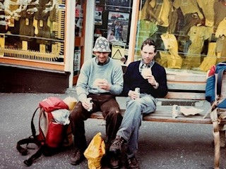
Next day we tramped into Brechin, a clean and friendly place. Sitting on a bench in a small square, eating fresh baps, we must have looked candidates for Salvation Army assistance because we received two offers of pots of tea, whilst the local newsagent sent across orange juice and Mars Bars!!
Not wishing the walk to finish, we ignored the next four signs to Montrose (our finishing point), and took the other direction each time, passing Kinnaird Castle and Montrose Basin. Having collected tops on nine consecutive days, we were still looking for something to climb.
We found it when the Scurdie Ness lighthouse keeper kindly unlocked his door and escorted us up the 172 steps to the top, giving us an interesting and entertaining lecture on the doings and misdoings of lighthouse keepers.

Feet washing then Party Time
A quick paddle in the cold North Sea and our walk was over. For our efforts we had covered 205 miles, climbed around 34,000ft, bagged 15 Munros and 3 Corbetts. We have memories that will last a lifetime.
Even so, a bucket and spade sounds like a good idea for the next week or two.
We checked in at the Montrose Hotel for the night, and a whole Blog may someday be written about our one night eventful stay!!!
A separate Blog will list the equipment we carried.
Please scroll right the way down the page to add a comment or 'like' the article or give it a star rating. Just knowing people are reading this and enjoying my stories means a lot to me! Thank-you. Normal Neville...


Love this article- everything from the detail of the hill routes across so many munros & Corbetts....through to