Trigpoints & Cairns - Love them or hate them? Top points...

I've collected some interesting facts to consider about Triangulation Points (Trigs) & Cairns.
Do you love or hate these man made apparitions that appear on virtually every hill that you ascend? Historically they've been a Love/Hate issue for many people.
Getting the Measure of Height
Triangulation Points were designed for the Ordnance Survey in around 1935, nearly 100 years ago, by Brigadier Martin Hotine when it was realised that Britain's mapping was hopelessly out of date.
Originally they were known as Hotine Pillars. In due course there were well in excess of 6000 throughout the UK.

The implementation of the system enabled accurate measurement of such things as Land Boundaries, Roads, Railways, Infrastructures.
More recently new measurement technology evolved such as Aerial Photography, Drones, Satellites, SatNavs, GPS etc.
Trig Bagging
Many are not aware, but there are now a number of clubs/ websites, that encourage people to visit and “collect” or “bag” Trig Points as a hobby.
These include Trigpointing UK and even an 'App' called TrigFindAR. The OS have launched GPS Waypoints to give realtime navigation cues and today there is a whole sport of Trig Bagging.
It has been suggested that these are suitable for a family day out. For example you could just collect Trig Points in a certain County or area. Look them up, many Trig Points are in low lying areas! But has anyone been to them all?

It was reported in 2016 that a gentleman called Rod Woodall had become the first person to bag every Trig Point in Britain, taking 13.5 years.
The total given was 6,190. He was joined at the final top by representatives from Ordnance Survey who presented him with a mounted OS bench mark (height marker) of his own.
Trig Art
Reading BALDHIKER (Paul Steele's website) I learnt that some Trig Points have been embellished by art work.
For example, the “Moel Famau Cairn” in the Clwydian Range in Wales has been painted three times.
First in Welsh tricolours, then with a black and white silhouette of local animals and insects and then...

... in 2025 it was painted again with three ground nesting birds, a curlew, a black grouse and a skylark to celebrate the area becoming an Area of Outstanding Natural Beauty.
And one Trig has become an official Art Installation.
At “The Wrekin” in Shropshire, the base of the Trig was decorated with clay tiles to celebrate local heros.
It was commissioned as part of the 2022 Queen's Jubilee legacy and unveiled the month that the Queen died.

Where do I stand on Trigs and Cairns?
Well I literally did stand on a Trig once for a very good reason (see later)! Personally I am in favour of Trig Points, and tolerate most of the Cairns.
Struggling to a new summit, especially as you get older (I am 87 now), the incentive of the Trig Point, the occasional glimpse through the mist, and the final few feet to what was often regarded as one of the highlights of the day... brought a sense of satisfaction, a sense of achievement.
On a good day the target signalled a time to have a brew and a nibble ...and to sit and, hopefully, admire the view. In really foul weather, like a full gale, we would sometimes crawl to our target, and when there we would hug it, throw our legs out backward and literally ride the wind. (Not conducive to good photography- see top of article!)
In a white-out on arrival at a Cairn we would give a sigh of relief that we had navigated correctly. Many a time we left a small pebble in memory of someone who loved the hills. It was more than a Triangulation Pillar or a Carin. It took on a personality. It was a friend.

Care for a Cairn?
So far as Cairns (piles of stones) were concerned, these are often helpful waymarkers, and a summit indicator when no Trig is present.
But sometimes there are too many Cairns, almost a continual row, detracting a little from the fun and skill of map reading, and occasionally leading you astray. Then again, a discreet small cairn indicating you should change direction, or confirming your correct direction, can be a reassuring sight.
I've published a number of songs and stories at Normalneville@YouTube about Scotland's Mountains including a podcast featuring a poem 'Ode to a Summit' in which I describe how many of us Munroists treat the cairn as our personal pew as we admire the mighty, breathtaking view. So why do some people hate them?
The Anti-Trig and Cairn Movement
There was a time in the 1980s when a few walkers decided that Trigs and Cairns were man made intrusions, and that they were an unnecessary eyesore and needed to be demolished.
I think that my first real indication of this was around 1986 when revisiting Ben Starav in Glen Etive to discover that the Trig Point no longer existed in its entirety but had been smashed into large chunks. It was rather like losing an old friend!

A number of Cairns also disappeared, being much easier to demolish and scatter that the Trig Points.
Personally I think that demolishing Trig points is an act of vandalism. They are part of History and are a reassuring sight. Trigpointing UK shows that in the North of Scotland, (North of Glasgow), around 27 Trig Points have been damaged and 25 have only a few remains to show as evidence of their existence.
Many other Trigs no longer exist having been lost to development, cliff erosion, etc.
Triggering Thoughts
Before I get onto a related confession, a few more facts.
The word Triangulation reflects the fact that the surveying was to be based on three points. This entailed building a pillar from which it was possible to see at least two other pillars, and by careful measurement using a theodolite and triangulation mathematics, heights and distances could be calculated.
The Trig points were substantial structures, built to last. They were mostly either cylindrical or pyramid shape, with few exceptions, and around 4ft in height.
It is not commonly known but there is usually as much, if not more, below ground than above ground. This means that a substantial concrete block is below ground, making them virtually immovable. This was to ensure that they were not affected by frost, soil erosion, animal movement and by visitors climbing and standing on them.

Most were built of concrete, but some were from local stone. Left to their own devices they have certainly stood the test of time. Each Trig was the work of several men, and the total weight of the equipment they carried could be as much as about 200 lbs.
There are two metal insertions in most Trig Points. The first is a three armed grooved “Spider” which is inserted at the top of every column.
This “Spider” is/was used to rest the theodolite, (surveying implement), precisely in its grooves.
There is also often a Brass Plate lower down on the column which is termed a Flush Bracket. This normally bears letters and an arrow. The letters are usually something like OSBM. This stands for Ordnance Survey Bench Mark.

The tip of the arrow indicates exactly where the column was measured to and the height above sea-level recorded. Sea level, for some reason, was calculated as being the average sea level at Newlyn in Cornwall. All OS UK mapped heights appear to use this as their base.
A symbol for the location of a triangulation pillar is marked on the Ordnance Survey Maps. It is a triangle, either black, blue or, in Ireland, red.
The highest “Trig Point” in the UK is, not surprisingly, on Ben Nevis, being at 1344m. The majority are on the highest point of their area. The lowest is apparently at Little Ouse, Cambridgeshire, which is 0.533m below sea level.
Oops!! Don't Get Too Trigger Happy!
Are you sure that you have done all the Munros and other peaks that you think you have?
You see, not all trig points are situated at the highest point of a mountain. The surveyors were more interested in ensuring that at least two other Trig points were visible, rather than that the Pillar indicated the highest point, otherwise triangulation measurements would not work.
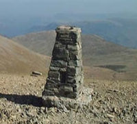
One example is the English Lake District mountain Hellvellyn which hosts a Trig Point on a flat plateau.
The Trig Point is apparently situated about 100 metres distance from the True High Point and is one metre lower than the true high point.
Another example is on Kinder Scout. This mountain's true highest point is 636m on top of a boggy mound, whilst the Trig Point at 633m is not the actual summit.
Most climbers accept that the Trig Point is at the true summit, so it is technically possible that sometimes they have not actually been to the true summit!!
Moving to Dartmoor, the hill Yes Tor boasts a Trig Point at 619m, but a nearby highpoint by the name of High Willhays (1km away) is actually taller at 621m, but has no pillar, just a cairn.
I hope that the purists among you will not now lie awake at night, pondering whether you have really done all the summits that you thought you had. Don't worry, I don't, and neither should you.

Some reputable societies, such as the Munro Society, still check the precise height of Scotland's highest peaks and it has been reported that the O.S. may often be incorrect by up to about a metre, and possibly more.
One of my favourite websites and forums, UKClimbing contains an article by Alan Dawson (who maintains lists of mountains called Grahams and Marilyns) which suggests that the O.S. Maps list an incorrect height on approximately half the Mountains in Britain! Admittedly many by only about one metre.
The few inches that turn a mountain into a Munro are essential to those who worship at the Munro Table and make a huge difference to the local economy of nearby campsites, hostels, hotels and amenities. Over the years several Munros have been demoted or promoted because of that extra inch or so.
How to convert a Corbett into a Munro
Leathad an Taobhain is the 6th highest Corbett, and is situated on the Highland/ Perthshire Border at GR821858 (can you still do Grid References?!).
It is 2992ft and needs just another 7.87 ft to be a Munro. However it has quite a tall cairn and if you stand on it and raise your arms whilst waving a sandwich then you should just be able to reach the magical 3000ft mark.
I did just that- see photo! Also see if you can spot this image, with some enhancements... in my song and video called "Call of Scotland" ! But now the confession...

Beware People Who Tamper with Cairns- a True Anecdote
Cairns are heavily relied on to indicate the highest point of a Hill.
It would be extremely difficult to move a Trig Point. However, Cairns are generally just a random pile of loose stones and boulders collected from the nearby environment, and are more easily moved. If there is no Trig Point then there is generally a Cairn in its place.
One misty day in 1994 our team was one member short. We were collecting Corbetts (Scottish mountain over 2500ft) and we had decided on Sow of Atholl, 803m, 2634ft. It's alongside the A9 just South of Dalwhinnie and this would be our 148th Corbett.
Having climbed it on a grey damp day we decided to make the day slightly more memorable. The summit was rather a rounded hump. One of our team was missing today, so we plotted a cunning plan.
We would demolish the Cairn and rebuild it just a few meters away. This would mean that when our missing team member visited this Corbett to catch us up, he would possibly miss the real summit and we could forever remind him that he had missed a Corbett out.

We had christened the new summit with a flask of hot water so that it wasn't quite as cold. In view of what I have said earlier in this article, this was not one of my proudest moments. I often think that I should return and restore order!!
Munro Magic
Consider that Sir Hugh Munro surveyed Scotland's Mountains in the 1890s, and Trig Points only came in 40 years later. As a one man team, carrying all his own kit, and measuring as he went along, he did an amazing job.
His height readings and numbers of Mountains and their subsidiary tops have stood the test of time. He concluded originally (1891) that there were 538 summits at or exceeding 3000ft, of which 283 were Munros (i.e. exceeding 3000ft). These numbers have altered, but not significantly, despite all new technology.

He was a one-man Ordnance Survey with virtually no amenities.
There have been a number of changes to the list of Munros, so if you wish to complete those that Munro himself believed to be Munros... you should also complete the 'Munro Tops' and possibly the highest Corbetts as well!
I hope this article Triggered some interesting thoughts for you. For stories and songs please check out my normalneville channel and maybe share some of the songs with others ... so that I know someone is listening! 👍🤞😁


Comments